6-27-11
Artificial Reef Pre-deployment Survey
Floyds Folly Permitted Area 6-27-11
Final Report

Prepared for:
The City of Jacksonville
Water Quality Branch
Environmental Quality Division
Environmental & Compliance Dept.
407 N. Laural Street
Suite 300
Jacksonville, FL 32202
Prepared by:
TISIRI Corp
![]()
10752 Deerwood Park Blvd. South
Suite 100
Jacksonville, Fl 32256
Summary:
TISIRI identified and survived an area of seafloor within the boundaries of the Floyds Folly area (Permitted Area SAJ-2007-261) on 6-27-2011. Results of the survey efforts suggest the area is adequate to place the anticipated concrete artificial reef materials. Divers that participated in dive survey and data collection efforts included Joe Kistel, Ed Kalakauskis, Nate Tucie, Jim Davis, Daniel Hughes, and Denise Hughes.
Site Selection:
A location within the FF permitted area was to be identified and surveyed to determine its adequacy to accept concrete artificial reef material. The site selected and surveyed is referenced in the graphic below.

To start, Capt Park directed The Native Diver II to the “FF Live Bottom” site as noted in the image above (30 09.756 -81 09.521). From there, the sonar equipment aboard the Native Diver II (Furuno 1650f) was utilized to investigate the hardness and profile of the sea floor. East-West transects were conducted in a southerly direction while the Furuno display was monitored. Although there appeared to be acceptable areas for a deployment in this area the overall depth was shallower then expected (around 65 feet) and the sonar suggested questionable areas of bottom. When taking these considerations into account, as well as trying to find more depth, the boundaries of the FF Permitted reef area began to come into question. It was decided to investigate the North East section of FF and the location, noted by the yellow pin in the image above, was selected to perform the scuba diving portion of the survey. This area was over 70 feet deep and appeared flat and free of obvious live bottom according to the sonar instrumentation.
The image below identifies the selected site in reference to the Mayport Jetties and St. Augustine Inlet.

The selected location (30 10.265, - 81 09.042) is roughly .4 miles from the closest possible FF area boundary and .4 miles (at a heading of approximately 50 degrees) from the existing 2009 artificial reef (30 10.034, - 81 09.322). As the image above illustrates the surveyed location is just over 21 miles from the Jacksonville Mayport Jetties while about 19.4 miles from the inlet at St Augustine.
Pre-Deployment Scuba Dive Survey:
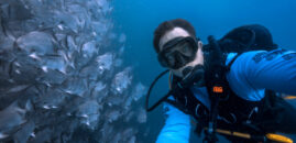
Once the site referenced above was identified, 3 diving team pairs entered the water for further site analysis. Divers performed a 300 foot diameter circular sweep, sampled sediment, observed marine life, photographed/videoed the area, and probed the sea floor.
During the dive efforts a thermo cline was observed at 40 feet and the temperature on the sea floor was about 75°F. Visibility at the sea floor was estimated to be 20 feet and no significant current was noticed.
Radial Sweep Circular Survey:
Two dive teams, both pairs with a marked line reel at 150 feet, secured the end of their reels to the anchor. The anchor served as the benchmark and center point of the area surveyed. The dive teams then traveled at a heading of 90° from the anchor until they reached their 150 foot marks. From that point, one dive team turned towards the north and the other team towards the south and, with their real lines taught, began to move away from each other. Each dive team swam a half circle completing the sweep once they reached 180°. Combined, both teams covered the entire circular area (diameter 300 feet).
Observations:
- No obvious live bottom such as natural reefs, sponge beds, and/or gorgonian forest were encountered within the 300-foot diameter area swept.
- The bottom appeared primarily flat with a stiff sandy bottom substrate. Very little ripples were observed in some areas.
- The bottom substrate was primarily sand with some larger aggregate including shell pieces.
- Invertebrate life observed included sea stars, sea urchins, and jelly fish.
- The few fish observed included sand perch, gobies, juvenile jacks, and a tomtate.
Marine life photos:


Sediment Probing:
Metal rods were use to randomly probe the sea floor throughout the area surveyed. The sea floor firmness, noted by the depth the probe penetrates the substrate, perhaps provides some indication of future reef materials ability of not sinking into the sea bed. The diagram below shows the depths of probe penetration at various locations of the surveyed area. On average, the probes penetrated roughly 4 inches deep indicating a firm, stable substrate.

Sediment Sampling:
Sediment samples were collected to determine the total composition of sand grain/particulate sizes. An extraction pipe, constructed from 0.75-inch diameter PVC, was used to collect vertical columns of sediment.
Three samples were collected at random areas within ten feet of the bench mark (anchor). Two sediment samples were collected with the extraction pipe mentioned above, and a third was collected using a shallow hand shovel technique. The third sample was collected in this fashion to better demonstrate the large aggregate materials on the sea floor that the extraction pipe was limited in collecting. The two “cored” samples were analyzed and combined generating the results in Table 1 below.
Table 1: Sediment Analysis

The results above indicate over 95% of the total sample consisting of large to medium sized sand. The picture shows the distribution of sediment sizes.

The third sample was run through the No. 6 sieve to show that the sea floor has substantial amount of large aggregate pieces. A picture of the aggregate that was not collected by the extraction pipe is shown below.

Water Sample, Salinity Measurement:
A water sample was collected at the sea floor, near the bench mark, to measure salinity. A Leica Model 10419 refractometer was used to take the salinity measurement. The water sample measured a salinity value at 36%.
Other considerations:
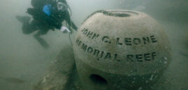
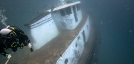
Divers also visited the nearby artificial reef that was deployed in 2009. The existing reef is approximately .4 miles away from the surveyed area discussed in this report. Since the reef to be deployed will consist of the same type of material as the existing reef, observations of the 2009 reef could provide some indication of how the new reef may appear in a couple of years.
Captain Park anchored the Native Diver II slightly to the West of the center of the reef. Divers entered the water, descended, and attached their reels to the anchor and headed toward the East. Reef material was encountered within 30 feet. The first divers on the site immediately encountered a large nurse shark.
Divers navigated around the center portion of the reef and noted the highest area of relief at 12 feet above the sea floor. This high point was a stacked pile of box junction-type concrete boxes. Divers verified the center area of reef after encountering the benchmark rod Joe Kistel and John Perkner placed a year ago.
General observations:
-Visibility 25 feet at the sea floor
-Water temp at sea floor around 75 degrees
-Some of the fish encountered included tomtates, sheephead, flounder, barracuda, amber jack, and sea bass.
-Reef material had obvious evidence of encrusting growth but it did appear “more clean” then anticipated.
-The most densely populated fish species were the tomtates
Pictures of the reef below:


More pictures and video of this reef site; click here.
Conclusions:
Based on the results of the survey efforts, TISIRI believes the area located at 30° 10.265’ N, 81° 09.042’ is adequate for the future deployment of concrete artificial reef materials.
-The recommended site is within FF permitted area (Permit # SAJ-2007-261).
-No obvious signs of “live bottom” were discovered within the area surveyed and 200 feet outside the surveyed area boundaries.
-Sediment penetration suggests a firm substrate base.
-Sediment analysis suggest primarily medium to large sized sand grains which implies less probability of material sinking into the substrate.
-The average depth of the site appeared to be around 72 feet based on scuba divers instrumentation. This depth allows for over 20 feet of relief of reef materials to stay within the permit requirements of a 50 foot sea surface clearance.
Sediment photographs:


Video:
-Pre-deployment survey @ 30°10.265’N, 81°09.042’W
Special Thanks:
-The City of Jacksonville (Especially Dana Morton, Jody McDaniel, and Jim Suber)
-The FWC
-Captain Steve Park and the Native Diver II
-Nassau Web Design
-JRRT Participants
-Office Suites Plus
-Marine Science Research Institute of Jacksonville University

[…] http://www.tisiri.org/ff-predeployment-survey-dive/ […]
excellent points altogether, you simply won a emblem new reader.
What could you recommend about your put up that you simply made some days ago?
Any positive?